Geo-ICT implementation in Elephant Movement Monitoring
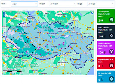
Protecting wildlife habitats and migration routes is crucial to prevent man-animal conflict. To achieve this, Chief Wildlife Warden, Odisha partnered with SPARC to develop a web-based GIS portal and mobile app for wildlife inventory, incident reporting, and monitoring in an eastern state of India. The portal includes dynamic real-time data, live feeds, and GIS-based maps for effective decision-making.
The mobile app records more than 1000 data points daily, providing a comprehensive data bank for elephant movement, habitual patterns, conflicts, and hazard points. The application is integrated with an alert broadcast system to inform local communities and other field functionaries to avoid elephant depredation.
- GIS-based Web Portal
- iOS and Android Mobile App
- GIS-MIS integrated Dashboard
DETAILS
Client: Chief Wildlife Warden, Odisha
Project cost: USD 275,000
Solutions: Geodatabase development | Development of WebGIS application for management of protected areas, with a special focus on elephant movements | Development of Mobile based elephant sighting and tracking application | Development of Mobile based alert system f