Paddy Crop Assessment and Transparent Procurement
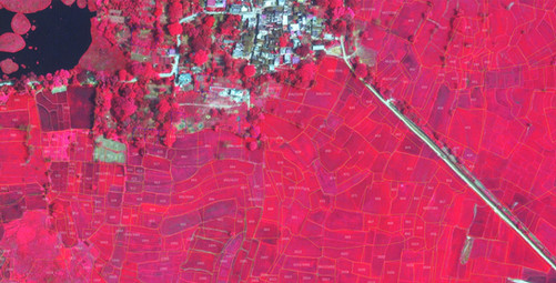
Imagine a solution that could analyze and monitor crops in real-time, preventing incorrect procurement and saving millions of rupees in the process. At SPARC, we made this a reality. Our customized solution utilized real-time satellite imagery data sets from an astounding 120+ satellites, covering 51 thousand villages. This enabled us to provide our client with an in-depth analysis of paddy crops at land parcel level, allowing procurement agencies to prevent procurement from false claims, thereby benefiting small and marginal farmers.
By leveraging the latest advancements in satellite imagery and AI/ML - our solution raised flags for discrepancies and facilitated rapid decision-making. As a result, we were able to significantly decrease their procurement costs by a whopping USD 300 million annually.
We also assisted the State Govt. to achieve the coveted e-Governance SKOCH Award 2022, Special Jury Award (FICCI), and nominated for the Planet Global Award 2022.
- Development of Land use intelligence model
- AI/ML based geospatial processing crop identification using 3-meter resolution
- Mobile GIS App for simultaneous collection of location service based field data by thousands of field officers
- Decision Support System for Monitoring Reporting and Verification
DETAILS
Client: Food Supplies and Consumer Welfare Department & Odisha Space Application Centre (ORSAC)
Project cost: USD 12.5 Million
Solutions: AI/ML based Satellite Image Analysis| Cadastral mapping | Web GIS application development (on AWS cloud)| Mobile field verification app | Data analytics (Big data analysis comparing farmer reporting with legacy data for past 3-4 years)