Planning of Cyclone Resilient Infrastructure
On 29th October 1999, a super cyclone slammed Odisha with a wind speed of 270-300 kmph, accompanied by torrential rain ranging from 400-867 mm over 3 consecutive days (October 29-31, 1999). It left a trail of destruction claiming 9893 human lives displacing millions, decimating hundreds of habitats, and washing away thousands of houses.
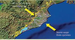
SPARC assisted Baird and Associates (an organization engaged by Canadian International Development Agency for damage assessment and cyclone resilient infrastructure planning) in mapping and planning a cyclonic storm surge embankment-cum-coastal highway.
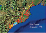
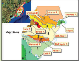
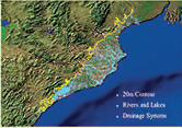
The assignment included mapping roads, settlements, rivers, and drainage systems below 20 m ground elevation. Modeling was conducted to compute probable surge height due to the combined effect of rain and high tide.
Surge protection, saline, and river embankment were designed to analyze the Doab areas (between two major rivers) and their vulnerability. GIS provided unique visualization of disaster risk vulnerability and helped effectively plan disaster-resilient infrastructure.
DETAILS
Client: Baird and Associates, Canada
Project cost: Confidential
Solutions: Surge protection embankment plan | GIS visualization of disaster risk vulnerability