Web GIS Based Water Consumer Mapping
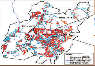
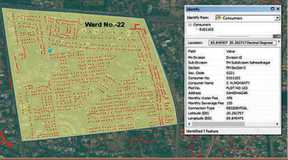
SPARC was assigned the task of development of a Web GIS based water utility consumer mapping for Bhubaneswar, the State Capital of Odisha. We developed a comprehensive geodatabase depicting location and attributes of all water and wastewater utility assets (pipeline, sewerage line and associated installations) and carried out a GPS survey of consumer locations as per consumers' record provided by the Public Health Rent Sub-division.
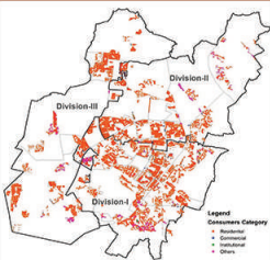
The water and wastewater utility asset and consumer locations with key attributes (consumer number, name, address, monthly demand, payment, outstanding arrears etc.) were integrated in a web-enabled GIS system with role-based information access for spatial analysis and decision making in revenue administration (demand vs. collection), network planning and decision making.
GIS based water utility consumer and asset data with consumer statistics, household coverage, water metering, demand collection, operation and maintenance expenses, etc. are vital for effective and efficient operation of water and sanitation assets and subsequent policy and management decisions for maintaining consumer satisfaction.
DETAILS
Client: TES Consortium (JICA Assisted Odisha Integrated Sanitation Improvement Project)
Project cost: Confidential
Solutions: Consumer location survey in different PH divisions | Web GIS-based water and sewerage consumer information system