July 12, 2023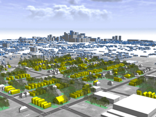
Critical Role of Geospatial Analysis in Urban Planning & Development
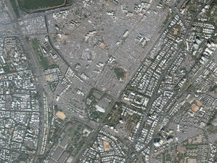
India is a rapidly developing country with a large and growing urban population. With this growth comes the need for effective urban planning and development. Geospatial analysis is a critical tool in achieving this goal. By using geographic data to analyze and understand spatial relationships, geospatial analysis can provide insights into suitable locations for development, areas requiring infrastructure development, and existing land use patterns.
Geospatial analysis is the process of using geographic data to understand spatial relationships and patterns. It involves the use of geographic information systems (GIS) software to analyze and manipulate data. The process typically involves collecting, organizing, and analyzing data from a variety of sources, including satellite imagery, aerial photography, and survey data. The tools used in geospatial analysis include GIS software, satellite imagery, and aerial photography.
Geospatial analysis plays a critical role in urban planning and development in India. It helps in identifying suitable locations for development, such as areas with adequate infrastructure and access to transportation. It also helps in identifying areas that require infrastructure development, such as areas with poor access to clean water or reliable electricity. Geospatial analysis can also provide insights into existing land use patterns, helping urban planners to make informed decisions about zoning and development.
Several successful urban planning and development projects in India have utilized geospatial analysis. For example, the Delhi Metro Rail Corporation used geospatial analysis to plan the routes and stations for the Delhi Metro. The project was completed on time and under budget, and has been credited with reducing traffic congestion and air pollution in the city. Another example is the Mumbai Urban Transport Project, which used geospatial analysis to plan the expansion of the city's transport infrastructure.
While geospatial analysis is a powerful tool, it is not without its limitations. One major limitation is the availability of accurate and up-to-date data. In many cases, data may be incomplete or out-of-date, making it difficult to make informed decisions about urban planning and development. Another challenge is the lack of technical expertise and resources in many parts of India, particularly in rural areas.
Implementing geospatial analysis in urban planning and development also presents challenges. One major challenge is the need to involve multiple stakeholders, including government agencies, private sector developers, and community groups. There may be differing priorities and perspectives among these groups, making it difficult to reach consensus on urban planning and development decisions.
Geospatial analysis plays a critical role in urban planning and development in India. By providing insights into spatial relationships and patterns, geospatial analysis can help urban planners to make informed decisions about development and infrastructure projects. While there are challenges to implementing geospatial analysis in urban planning and development, the benefits are clear. To effectively utilize geospatial analysis in urban planning and development, stakeholders must work