July 12, 2023
The Power of Big Data in Geospatial Industry
Geospatial technology has been revolutionizing industries, from agriculture to urban planning, for years. However, with the advent of big data, geospatial technology has entered a new era of efficiency, precision, and innovation. In this blog post, we will explore the use of big data in the geospatial industry and how it's driving growth, insights, and sustainability.
What is Big Data?
Big data refers to the vast amounts of structured and unstructured data that is generated by businesses, individuals, and sensors every day. This data is too complex to be processed by traditional database systems and requires specialized tools and techniques to extract insights and value from it.
Big Data in Geospatial Industry
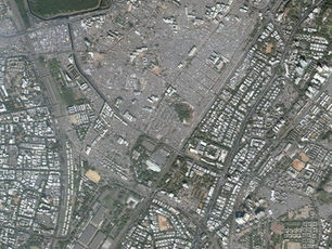
Geospatial industry deals with the acquisition, analysis, and visualization of geospatial data, which includes geographic, geological, and environmental data. Big data has transformed the geospatial industry in the following ways:
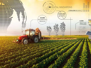
Data Acquisition: The use of big data has made it easier and more cost-effective to acquire geospatial data. With the use of sensors and remote sensing techniques, massive amounts of geospatial data can be captured, processed, and analyzed in real-time. This data can be used to map and monitor environmental changes, natural resources, and urban areas.
Analytics: Big data analytics enables geospatial professionals to derive insights from vast amounts of geospatial data. By using advanced analytical tools and machine learning algorithms, geospatial professionals can identify patterns, trends, and relationships in geospatial data. This enables them to make informed decisions and predictions in areas such as agriculture, urban planning, and natural resource management.
Visualization: Big data enables the creation of more precise and accurate visualizations of geospatial data. With the use of big data analytics and 3D modeling, geospatial professionals can create detailed visualizations of complex geospatial data. These visualizations can be used to identify and visualize patterns in environmental changes, natural resources, and urban areas.
Sustainability: Big data is driving sustainability in the geospatial industry by enabling better decision-making and resource management. By using geospatial data and big data analytics, businesses and governments can make informed decisions about the management of natural resources, energy, and water. This leads to more efficient and sustainable use of resources.
Conclusion
The use of big data in the geospatial industry has transformed the way we acquire, analyze, and visualize geospatial data. By enabling real-time data acquisition, advanced analytics, and precise visualizations, big data is driving growth, insights, and sustainability in the geospatial industry. As we continue to generate vast amounts of geospatial data, the use of big data and analytics will become increasingly important in the geospatial industry.